China International Security Solution Corporation Limited:
A Front-End Platform for CCP Military Trade, Geospatial Control, and Belt and Road Security Operations
China International Security Solution Corporation Limited (中国国际安防科技有限公司, hereafter CISSC) is not a household name in the West. It does not trade publicly in New York or London, nor does it market itself aggressively to Western consumers. Yet multiple publicly available documents show that CISSC sits at the intersection of security technology, satellite communications, geospatial intelligence, and China’s Belt and Road Initiative (BRI)—all within the framework of the Chinese Communist Party’s (CCP) military–civil fusion strategy.
This article outlines what CISSC is, who it partners with, and why its activities deserve scrutiny from a U.S. and allied national-security perspective.
1. Corporate identity and positioning
English name: China International Security Solution Corporation Limited
Chinese name: 中国国际安防科技有限公司
Core positioning: International security solutions, with emphasis on communications, geospatial information, and overseas projects linked to BRI.
While CISSC presents itself as a commercial security and technology provider, its documented partnerships and state-linked activities indicate alignment with CCP strategic priorities, not merely market demand.
2. Embedded in military–civil fusion: official evidence
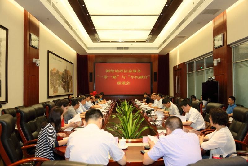
In August 2017, CISSC participated in a high-level, state-organized symposium titled:
“Surveying and Mapping Geospatial Information Services for the Belt and Road Initiative and Military–Civil Fusion”
At the symposium convened by the National Surveying and Mapping Engineering Technology Research Center (国家测绘工程技术研究中心) on 23 August 2017, senior officials and representatives from China’s national geospatial, satellite, defense and research establishments attended and spoke. Key participants included:
National Administration of Surveying, Mapping and Geoinformation (国家测绘地理信息局) — represented at senior level by Deputy Director Li Pengde (李朋德);
Chinese Academy of Surveying and Mapping (中国测绘科学研究院) — leadership represented by Party Secretary/Director Zhao Jicheng (赵继成) and other institute officials;
Academician Tong Qingxi (童庆禧) of the Chinese Academy of Sciences;
Central Military Commission Joint Staff Department (中共中央军委联合参谋部);
Central Military Commission Equipment Development Department (中央军委装备发展部);
Central Military Commission International Military Cooperation Office (中央军委国际军事合作办公室);
China Satellite Navigation Office / China BeiDou Navigation Satellite System Management Office (中国卫星导航系统管理办公室);
People’s Liberation Army National Defense University / PLA National Defense University (国防大学);
State Oceanic Administration (国家海洋局);
China Geological Survey (中国地质调查局);
China Remote Sensing Applications Association (中国遥感应用协会);
Silk Road International Foundation (丝路国际公益基金); and
senior leaders from the relevant bureaus and departments of the National Administration of Surveying, Mapping and Geoinformation (国家局相关司室).
During the meeting the attendants focused on how positioning, geospatial and spatio-temporal information should be organized and mobilized to support both the Belt and Road Initiative (一带一路) and national military–civil fusion (军民融合) priorities. Major agenda items and themes included:
Strategic framing — official statements stressing that geospatial and positioning data are foundational national infrastructure and must be integrated into long-term BRI and defense planning;
Capability gaps and weaknesses — reviews and technical assessments identifying current shortfalls in data-sharing mechanisms, standardization, legal frameworks, overseas operational support and platform interoperability;
Mechanism and platform development — proposals to create institutional mechanisms and shared platforms to better coordinate domestic and international geospatial efforts and to ensure deep integration between civilian agencies, commercial entities and military requirements;
Standards, law and governance — recommendations to accelerate unified standards, legal support, and management systems for overseas geospatial work;
Project and resource coordination — plans to marshal national resources, deploy expertise overseas, and coordinate state, provincial and corporate participants for BRI geospatial projects; and
Capacity building and overseas service provision — emphasis on exportable geospatial capabilities, overseas mapping and data services, and training/capacity building for partner countries along BRI routes.
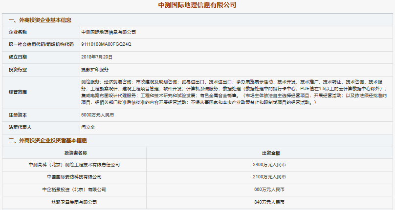
A concrete outcome of the session was the ceremonial unveiling of a new joint venture: Zhongce International Geospatial Information Co., Ltd. (中测国际地理信息有限公司) aka China International Geoinformation Corporation Limited— a jointly established firm with founding stakeholders that included Chinese Academy of Surveying and Mapping (中国测绘科学研究院) (via its wholly owned company Zhongce Gaoke (Beijing) Surveying & Engineering Technology Co., Ltd.), China Silk Road Group (中国丝路集团) (and its subsidiaries China International Security Solution Corporation Limited / China International Security Technology Co., Ltd. (中国国际安防科技有限公司) and China Silk Road Satellite Group Co., Ltd. (中国丝路卫星集团有限公司)). At the unveiling, senior figures including Li Pengde (李朋德), Academician Tong Qingxi (童庆禧), Zhao Jicheng (赵继成) and Yan Lijin (闫立金) participated and set out a plan to leverage existing Silk Road platforms to accelerate overseas geospatial capability construction and business deployment.
The meeting concluded with directed follow-ups: compiling the conference materials as an authoritative reference for implementing geospatial services for BRI and military–civil fusion; establishing a consultation committee to advise on geospatial support for BRI and military–civil fusion; and drafting and initiating a national plan for surveying and mapping/geospatial services to underpin major national engineering and overseas projects.
At this event, a new joint venture—Zhongce International Geospatial Information Co., Ltd.—was formally unveiled. CISSC was one of the founding shareholders.
The stated purpose of this venture was explicit:
to support Belt and Road projects
to integrate geospatial intelligence
to serve military–civil fusion objectives
to enhance the CCP’s ability to protect and manage overseas interests
This is direct, on-the-record confirmation that CISSC operates inside China’s military–civil fusion system, not adjacent to it.
English name: China International Geoinformation Corporation Limited
Chinese name: 中测国际地理信息有限公司
Unified Social Credit Code / Org. code: 91110108MA00FGQ24Q
Business scope (selected): surveying & mapping services; economic and trade consulting; municipal planning consulting; import/export of goods and technology; exhibition organization; technology development, transfer and services; engineering survey & design; construction project management; software development; computer system services; data processing (exclusions apply); integrated circuit layout design agency services; engineering & technical R&D; sale of non-ferrous metal alloys; etc.
Silk Road Satellite Group Co., Ltd. (丝路卫星集团有限公司) — RMB ¥8,400,000
Tong Qingxi (童庆禧) — Profile
Tong Qingxi is an academician of the Chinese Academy of Sciences (中国科学院院士) and a senior researcher at the Institute of Aerospace Information Innovation, Chinese Academy of Sciences (中国科学院空天信息创新研究院). He is also an academician of the International Eurasian Academy of Sciences. Tong has held senior leadership roles in China’s remote sensing and space-science community, including serving as the former chair of the Expert Committee of the National Remote Sensing Center (国家遥感中心专家委员会). He has served as Vice-Chair or senior officer in multiple professional bodies such as the Space Remote Sensing Professional Committee of the Chinese Society for Space Research (中国空间科学学会空间遥感专业委员会), the Chinese Geographical Society (中国地理学会) (standing council member), and as Secretary-General of the National Remote Sensing Committee (中国遥感全国委员会); he has also served on the board of the Asian Association on Remote Sensing.
Education and career highlights: Tong received his bachelor’s degree from the Odessa Hydrometeorological Institute (then USSR). Over a long research career he has led and served in China’s principal remote sensing institutes: he was director of the Aerospace Remote Sensing Center (中国科学院航空遥感中心) in the mid-1980s, later led research units at the Institute of Remote Sensing Applications, Chinese Academy of Sciences (中国科学院遥感应用研究所) and the Institute of Remote Sensing and Digital Earth, Chinese Academy of Sciences (中国科学院遥感与数字地球研究所), and since 2020 has been affiliated with the Institute of Aerospace Information Innovation. Tong’s technical domain covers space-borne remote sensing, satellite applications, and the integration of remote sensing into national surveying, mapping and geospatial services.
National Surveying and Mapping Engineering Technology Research Center (国家测绘工程技术研究中心) — Overview
The National Surveying and Mapping Engineering Technology Research Center (国家测绘工程技术研究中心) was approved for establishment in 2009 by the Ministry of Science and Technology and completed formal acceptance in 2014. The center is overseen by the Ministry of Natural Resources (自然资源部) and is hosted by the Chinese Academy of Surveying and Mapping (中国测绘科学研究院, CASM). The research center’s industrialization and project-execution legal entity is Zhongce Xintu (Beijing) Remote Sensing Technology Co., Ltd. (中测新图(北京)遥感技术有限责任公司), which supports the center’s applied R&D and technology transfer activities.
The Center functions as a national-level engineering technology hub for China’s surveying and geospatial industry. Its mission is to bridge basic surveying research and industrial application by operating as an innovation, incubation, technology-integration and service platform. R&D priorities span: surveying equipment development; spatial data acquisition and processing; GIS and geospatial platform development; new measurement techniques and processes; and absorption and re-innovation of imported technologies. The center’s work covers multi-layer space acquisition (spaceborne, airborne, low-altitude and ground), and supports the integration needs of an “air-space-ground” unified mapping system.
Key facilities and capabilities already established at the center include:
a BeiDou/GPS dual-mode receiver chip testing laboratory;
a digital television geographic information application test laboratory;
a pilot promotion base for new technologies;
end-to-end workflows for data acquisition → processing → application service delivery.
Applied results from the center have been deployed across broadcasting/TV, urban management, disaster response, environmental protection, agriculture, national defence support, transportation, and navigation services. The Center explicitly positions itself to accelerate the industrialization of surveying technology, the socialized application of mapping science, and capacity building for domestic and overseas geospatial projects — a mandate that aligns its outputs closely with both civil infrastructure and strategic-state requirements.
3. Partnership with Addvalue Technologies (Singapore)
CISSC’s international footprint is reinforced through cooperation with Addvalue Technologies Ltd, a Singapore Exchange (SGX)-listed company.
Relevant entities:
ADDVALUE TECHNOLOGIES LTD (Singapore, listed)
Addvalue Innovation Pte Ltd (100% subsidiary)
China International Security Solution Corporation Limited (CISSC)
In October 2015, Addvalue Innovation Pte Ltd signed a Memorandum of Understanding with CISSC to:
jointly develop and supply satellite communication terminals
support projects under the Belt and Road Initiative
provide customized and integrated communications solutions for overseas deployments
Satellite communications are inherently dual-use. They support civilian connectivity, but also:
command and control
remote coordination
secure data transmission
operations in infrastructure-poor or contested regions
From a U.S. export-control and sanctions perspective, this category of technology is consistently treated as high risk.
4. What Addvalue’s own filings reveal
Addvalue’s audited financial statements (FY ended 31 March 2020), reviewed by Mazars LLP (Singapore), confirm:
Addvalue Innovation Pte Ltd is wholly owned by Addvalue Technologies Ltd
It focuses on:
design, development, and distribution of telecommunications equipment
satellite communication products and services
The group maintains business development and marketing operations in:
Singapore
Hong Kong through wholly owned subsidiary Addvalue Global Limited
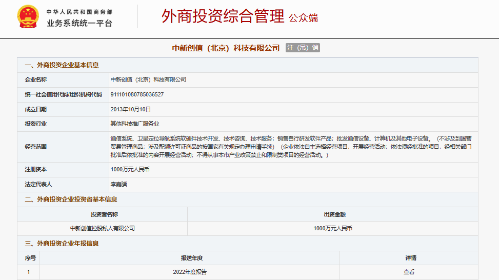
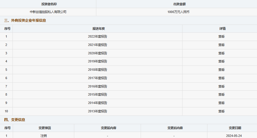
the People’s Republic of China through wholly owned subsidiary Zhongxin Chuangzhi (Beijing) Technology Ltd., Co.(中新创值(北京)科技有限公司) deregistered on 24 May 2024
While the filings are neutral in tone—as financial statements should be—the documented business scope aligns precisely with the cooperation announced with CISSC.
Strategic Collaboration Between China’s 7Star Communications and Singapore’s Addvalue Innovation
In early January 2019, 7Star Communications Technology (Beijing) Co., Ltd.(a/k/a Seven Star Communication Technology (Beijing) Co., Ltd.) signed a strategic cooperation framework agreement with Addvalue Innovation Pte Ltd, a 100% subsidiary of ADDVALUE TECHNOLOGIES LTD (Singapore). The agreement covers collaboration in small satellite control and data link operations and reflects a broader vision of integrating the companies’ technological capabilities across China, Singapore, and global markets.
About the Collaboration
The two firms outlined a strategy to:
leverage their respective strengths in satellite communication research, production, and service operations
co-develop next-generation satellite mobile communication solutions
provide enhanced hardware and operational services for global satellite mobile communication users
The agreement emphasizes principles of mutual benefit, complementary advantages, and deep collaboration, signaling an intention to build China’s strongest and globally leading satellite mobile communication provider.
Founded in August 2016 in Zhongguancun, Beijing, a hub for China’s high-tech innovation
Addvalue Innovation Pte Ltd
A Singapore-based subsidiary of ADDVALUE TECHNOLOGIES LTD, specializing in satellite mobile communication hardware and solution services
Brings global experience in satellite communications, device R&D, and backend operations
Already partnered with multiple international projects in satellite terminals and mobile communication solutions
Strategic Implications
While presented as a commercial cooperation, several factors suggest broader strategic significance:
Dual-use technology – Satellite communication terminals have both civilian and military applications, particularly in secure data links and mobile command capabilities.
Cross-border integration – The partnership links Chinese and Singaporean technology firms, creating channels for international deployment of satellite solutions aligned with China’s Belt and Road communications infrastructure.
Embedded network in China’s state ecosystem – 7Star’s collaborations with CETC 54th Research Institute and China Telecom’s BeiDou Innovation Center indicate ties to state and potentially military-linked projects.
In short, the collaboration between 7Star Communications and Addvalue Innovation is more than a standard commercial partnership: it is a strategic alignment between a Chinese high-tech state-connected enterprise and a Singaporean company with global satellite communications capabilities, enhancing China’s reach in satellite mobile communications.
5. Why this matters to the United States and its allies
From a Western policy and security lens, CISSC raises several red flags:
1. Military–civil fusion is explicit, not inferred
The company’s participation in PLA-linked forums and joint ventures is officially acknowledged by CCP-affiliated institutions.
2. BRI is treated as a security domain
CISSC’s role supports the CCP narrative that overseas infrastructure, logistics, and communications are part of a unified security space.
3. Third-country intermediaries reduce friction
By partnering with Singapore-based firms, CISSC benefits from:
reputational shielding
access to international supply chains
reduced initial scrutiny compared to PRC-incorporated entities
4. Legacy activities still matter
Although some of these partnerships date back to 2015–2017, they remain relevant today:
sanctions and export-control decisions are often retrospective
historical evidence is frequently used to rebut claims of “purely civilian” intent
6. Bottom line
China International Security Solution Corporation Limited should not be viewed as a conventional private security or technology company. Public records show it to be:
structurally aligned with CCP state objectives
operationally linked to PLA-adjacent ecosystems
active in satellite communications and geospatial intelligence
embedded in Belt and Road deployments framed as security infrastructure
For analysts, policymakers, and investors in the United States and allied countries, CISSC is best understood as a node in China’s outward-facing military–civil fusion architecture, rather than a neutral commercial actor.
Li Pengde: A Senior Architect of China’s State-Controlled Geospatial and Satellite Mapping System
Li Pengde is a senior Chinese state official and geospatial technocrat whose career sits squarely at the intersection of satellite mapping, national security, military–civil fusion, and overseas strategic expansion.
Born in October 1962 in Nanyang, Henan Province, Li has spent over four decades inside China’s state-controlled surveying, mapping, and geospatial intelligence system. He holds a PhD in photogrammetry and remote sensing and is a senior engineer by rank, combining deep technical credentials with long-standing political trust from the Chinese Communist Party (CCP).
Early technical foundation and overseas exposure
Li was trained at Wuhan Institute of Surveying and Mapping (now part of Wuhan University), one of China’s most important feeder institutions for national mapping, satellite, and remote-sensing cadres. In the late 1980s and early 1990s, he received advanced training in GIS cadastral applications at the International Institute for Aerospace Survey and Earth Sciences (ITC) in the Netherlands—an experience that gave him early exposure to Western geospatial standards and technologies.
This foreign training later became an asset when China began integrating international geospatial norms into its own state-dominated systems while retaining strict political and military control.
Rise through China’s mapping and satellite bureaucracy
From the mid-1990s onward, Li advanced rapidly through provincial and national mapping authorities, holding leadership positions in:
provincial surveying and mapping bureaus
foundational geographic information centers
national map review and approval bodies
satellite surveying and mapping application centers
Between 2009 and 2018, Li served as Vice Minister (Deputy Director) of the State Bureau of Surveying and Mapping, later renamed the National Administration of Surveying, Mapping and Geoinformation. During this period, China formally elevated geospatial data, satellite mapping, and navigation systems into core components of national security and military–civil fusion policy.
Notably, Li simultaneously oversaw China’s satellite surveying and mapping application infrastructure, a domain closely linked to the BeiDou navigation system, remote sensing, and military command-and-control support.
Role in military–civil fusion and Belt and Road integration
Li Pengde was a key official presence at high-level meetings explicitly dedicated to integrating:
geospatial intelligence
satellite mapping
military requirements
Belt and Road overseas projects
In these forums, mapping and geographic information were openly described as tools for:
protecting China’s “overseas interests”
supporting international infrastructure deployment
enabling defense and security coordination beyond China’s borders
This framing aligns precisely with the CCP’s military–civil fusion doctrine, under which civilian institutions and companies are required to serve defense and security objectives when needed.
Political standing
Li’s career reflects sustained political confidence from the CCP:
Delegate to the 10th and 11th National People’s Congress
Member and Standing Committee member of the 12th and 13th Chinese People’s Political Consultative Conference (CPPCC)
Graduate of the Central Party School provincial–ministerial level leadership program
Since 2018, he has served as Deputy Director of the China Geological Survey, an institution that plays a strategic role in resource security, territorial data, and overseas geological projects.
Connection to UN geospatial initiatives
Li’s professional domain overlaps with China’s push to shape global geospatial governance. In 2022, the UN Global Geospatial Knowledge and Innovation Center was formally established in Deqing, Zhejiang Province, following an announcement by Xi Jinping at the UN General Assembly.
While framed as a multilateral development initiative, the center reflects Beijing’s broader strategy of embedding state-controlled geospatial data capabilities into international institutions—an approach consistent with the career trajectory and policy priorities long represented by officials like Li Pengde.
In November 2023, Chinese state media confirmed that Li Pengde had been appointed Director of the United Nations Global Geospatial Knowledge and Innovation Center (UN-GGKIC), headquartered in Deqing, Zhejiang Province. The appointment became publicly evident following Li’s official meetings with senior local CCP leadership, including the Mayor of Huzhou.
With this move, a long-serving Chinese geospatial and satellite-mapping official—deeply embedded in China’s military–civil fusion system—assumed leadership of the first UN directly affiliated specialized institution established inside China.
This is not a routine technocratic appointment. It carries institutional, geopolitical, and security implications.
Why Li Pengde matters
From a U.S. and allied policy perspective, Li Pengde is not merely a technocrat. He represents a hybrid figure:
a trained geospatial scientist
a long-serving security-relevant bureaucrat
a trusted political actor within the CCP system
His presence at military–civil fusion meetings signals that China’s mapping, satellite, and geospatial sectors are not civilian backwaters, but centrally managed strategic assets with direct implications for defense, overseas operations, and global governance.
Zhao Jicheng: Former Party Secretary of a State Geospatial Institute and Senior Leader in China’s BeiDou Governance System
Zhao Jicheng is a senior Chinese geospatial official best understood as part of China’s state-controlled satellite navigation and positioning ecosystem, rather than as a neutral industry representative.
He currently holds the title of Executive Vice Chairman of the China Satellite Navigation and Location Services Association, while also being identified as the former Party Secretary of the Chinese Academy of Surveying and Mapping (CASM)—a core national-level research institution under China’s natural resources and geospatial governance system.
GLAC: Not a trade group in the Western sense
The China Satellite Navigation and Location Services Association (GNSS & LBS Association of China, GLAC) is often described externally as an “industry association.” Its own charter, however, makes clear that it is politically and institutionally embedded in the CCP system.
Key provisions from the Association’s charter state explicitly that:
The Association is guided by Xi Jinping Thought on Socialism with Chinese Characteristics for a New Era
It upholds the comprehensive leadership of the Chinese Communist Party
A CCP organization is formally established within the Association
Party activities are conducted as part of normal operations
Senior appointments and elections must be reviewed and approved by Party authorities
The Association is:
registered with the Ministry of Civil Affairs
supervised by the Central and State Organs Working Committee of the CCP
In short, GLAC is not an independent professional body. It is a Party-led coordination platform linking government agencies, state-owned enterprises, defense contractors, and selected private firms within the BeiDou / GNSS / location-based services ecosystem.
Zhao Jicheng’s institutional role
Zhao Jicheng’s background places him firmly inside China’s state geospatial–security nexus:
As former Party Secretary of CASM, he held the top political authority position in one of China’s most important national geospatial research institutes
CASM is directly involved in:
national mapping and surveying standards
geospatial data management
satellite navigation and positioning research
support for defense, security, and strategic planning needs
In the CCP system, the Party Secretary, not the president or director, is the ultimate authority. This role signals political trust and responsibility for aligning scientific and technical work with Party and state priorities.
Executive Vice Chairmanship and BeiDou governance
As Executive Vice Chairman of GLAC, Zhao Jicheng operates at a coordination level that connects:
BeiDou-related state-owned enterprises
military-linked research institutes (including subsidiaries of China Electronics Technology Group Corporation, CETC)
satellite manufacturers and integrators
navigation, positioning, and location-data service providers
The Association’s stated mission is to:
promote BeiDou deployment across industries
advance navigation and location services domestically and internationally
integrate research, application, and policy under unified Party leadership
Given BeiDou’s dual-use nature—civilian navigation and military command-and-control—this role is inherently security-relevant.
Vice chairs and standing directors include senior figures from:
CETC research institutes
China Aerospace Science and Technology Corporation affiliates
satellite application SOEs
national surveying and mapping institutes
This composition reflects system integration, not market pluralism.
Why Zhao Jicheng matters
From a U.S. and allied analytical perspective, Zhao Jicheng should be understood as:
a Party-aligned geospatial authority, not a neutral technologist
a coordinator within China’s satellite navigation and positioning governance system
a figure linking scientific research, industry deployment, and national strategy
His current title may sound technical or associative, but it sits inside a structure where civilian, military, and political objectives are deliberately fused.
Bottom line
Zhao Jicheng’s roles—past and present—illustrate how China’s satellite navigation and geospatial sectors are governed:
through Party leadership
via state-supervised associations
with explicit integration into national security and military–civil fusion strategies
Understanding figures like Zhao is essential to understanding how organizations labeled as “associations” or “industry groups” function in practice within the CCP system.
Relationship Between Zhongce International Geospatial Information Co., Ltd., the GNSS & LBS Association of China, and CCP Military-Industrial Entities
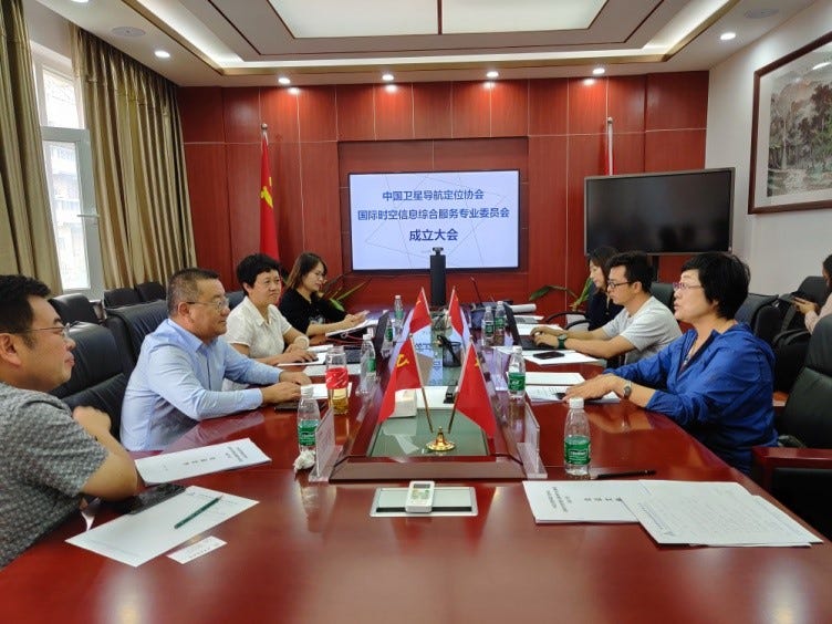
Zhongce International Geospatial Information Co., Ltd. (中测国际地理信息有限公司) occupies a central organizational role within the GNSS & LBS Association of China (中国卫星导航定位协会, GLAC) through its leadership of the International Spatiotemporal Information Integrated Services Professional Committee (中国卫星导航定位协会国际时空信息综合服务专业委员会). This committee was formally established in Beijing on 12 September 2020 with the approval of GLAC, a national-level industry association that serves as a coordination and policy-transmission platform for China’s satellite navigation sector under CCP supervision.
The founding meeting and first working session of the committee were chaired by Yan Lijin (闫立金), who simultaneously serves as Chairman of Zhongce International Geospatial Information Co., Ltd., Chairman of China Silk Road Group (中国丝路集团), and Director of the Silk Road International Foundation (丝路国际公益基金). In this capacity, Zhongce International functions not merely as a commercial entity, but as an organizational hub linking BeiDou internationalization efforts with Belt and Road–aligned overseas expansion strategies.
The committee’s leadership and membership structure demonstrates deep integration with CCP military, aerospace, and strategic technology institutions. Participants included:
Liu Dake (刘大可), Executive Vice President of GLAC, representing the association’s national policy-coordination role.
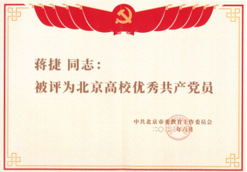
Jiang Jie (蒋捷), CCP member, Secretary-General of the committee and President of the National Development Institute at Beijing University of Civil Engineering and Architecture (北京建筑大学).
Lu Xiaochun (卢晓春), Deputy Director of the National Time Service Center, Chinese Academy of Sciences (中国科学院国家授时中心)—a core national infrastructure entity supporting precision timing for BeiDou and military systems.
Wang Yuxiang (王宇翔), General Manager of Piesat Information Technology Co., Ltd. (航天宏图信息技术股份有限公司), Vice Chairman of the Commercial Space Branch of the China National Defense Industry Enterprise Association (中国国防工业企业协会商业航天分会), member of the Beijing Municipal CPPCC, and a recipient of the CCP Central Organization Department’s “Ten Thousand Talents Program”.
Mo Xiaoyu (莫晓宇), Chairman of Chengdu Zhenxin Technology Co., Ltd. (成都振芯科技股份有限公司), a major BeiDou and military-grade integrated circuit supplier, and a graduate of the PLA Army Command College (中国人民解放军陆军指挥学院).
Additional members from regional spatiotemporal data and geospatial industry entities.
According to official statements at the meeting, the committee’s explicit mission is to advance the internationalization of the BeiDou Navigation Satellite System, promote integrated applications of navigation, communication, and remote sensing (通导遥一体化), expand overseas industrial deployment, and support Belt and Road Initiative projects through international cooperation, education, and research.
The committee itself was jointly initiated by Zhongce International Geospatial Information Co., Ltd., Beijing University of Civil Engineering and Architecture, the National Time Service Center of the Chinese Academy of Sciences, the Shanghai BeiDou Navigation Innovation Institute (上海北斗导航创新研究院), and other institutions, and was formally approved by GLAC.
In practice, this structure positions Zhongce International as a key civilian interface for CCP-directed satellite navigation strategy, operating at the intersection of commercial geospatial services, military-civil fusion, and overseas infrastructure expansion. Through GLAC and its specialized committees, Zhongce International participates directly in aligning enterprise activity with national policy objectives related to BeiDou deployment, defense-adjacent technologies, and China’s external strategic influence.
Investment in Shanghai BeiDou Navigation Innovation Institute (上海北斗导航创新研究院)
A approval record establishes a formal, government-approved commercial vehicle for BeiDou R&D and testing in Shanghai with mixed state and private capital. Notably, China International Security Solution Corporation Limited (中国国际安防科技有限公司) is explicitly listed as a 10% cash investor. The document confirms the project’s official purpose (high-availability, high-trust, high-precision BeiDou testing and technology transfer) and the government-directed structure for a “government-led, social-participation” operating model — a common arrangement for projects that combine civilian R&D with strategic state objectives (including timing, navigation, and positioning capabilities). That makes the entry valuable as a primary-source registry linking defense-adjacent actors to BeiDou commercialization and testing platforms.
English translation — Approval for the Establishment of Shanghai BeiDou Navigation Innovation Research Institute Co., Ltd.
Shanghai BeiDou Navigation Innovation Research Institute Co., Ltd. (Approval notice issued by the Qingpu District State-owned Assets Supervision and Administration Commission)
Document index: QC3304000-2018-002 Issuing authority: Qingpu District State-owned Assets Supervision and Administration Commission (青浦区国有资产管理委员会) Publication date: 2018-05-21 (approval dated 2018-05-18)
To: Shanghai Xihongqiao Business Development Co., Ltd. (上海西虹桥商务开发有限公司)
We have received your submission titled “Request by Shanghai Xihongqiao Business Development Co., Ltd. to establish Shanghai BeiDou Company” (document Huxi Shang [2018] No. 21). In accordance with the district government’s special meeting decisions and after review, we hereby approve as follows:
In-principle approval. In principle, approval is granted for your company, together with other state-owned and social capital participants, to jointly invest in and establish “Shanghai BeiDou Navigation Innovation Research Institute Co., Ltd.” (上海北斗导航创新研究院有限公司). This entity will serve as the operational company for BeiDou navigation R&D and technology transfer functions in Shanghai, providing high-availability, high-trust, and high-precision testing services, as well as services for technology transfer and transformation of technical results.
Registered capital and shareholding structure. The registered capital of Shanghai BeiDou Navigation Innovation Research Institute Co., Ltd. is RMB ¥30,000,000. The planned capital contributions and shareholdings are as follows (all cash contributions, paid in full at establishment):
Shanghai Xihongqiao Business Development Co., Ltd. (上海西虹桥商务开发有限公司) — RMB ¥10,800,000 (36%);
Shanghai Xihongqiao Navigation Industry Development Co., Ltd. (上海西虹桥导航产业发展有限公司) — RMB ¥10,200,000 (34%);
China International Security Solution Corporation Limited / China International Security Technology Co., Ltd. (中国国际安防科技有限公司) — RMB ¥3,000,000 (10%);
Organizational and legal compliance. Your company must, in strict accordance with the Company Law and the district government’s requirements, actively participate in the formation of Shanghai BeiDou Navigation Innovation Research Institute Co., Ltd. You should strengthen cooperation with various capital partners, fully leverage each party’s advantages, and form a government-led, socially-participatory, entity-based, professionalized, and market-oriented operating mechanism to promote platform construction. Upon receipt of this approval, please promptly complete business registration, tax registration, and related formalities in accordance with relevant regulations.
Signed and issued by: Qingpu District State-owned Assets Supervision and Administration Commission (青浦区国资委) Date of approval: 18 May 2018
Yan Lijin (闫立金) is a Chinese executive with a long career at the core of the CCP’s defense electronics export and military-trade system, particularly in South Asia.
Yan studied electronic components engineering at Xi’an Jiaotong University from 1982 to 1986, earning a Bachelor of Engineering degree. After graduating in 1986, he was assigned to China National Electronics Import & Export Corporation, a key state trading entity under the CCP system responsible for electronics and defense-related exports.
Beginning in 1993, Yan served as the resident representative of China National Electronics Import & Export Corporation in Pakistan, where he worked continuously for nearly two decades. According to later biographical accounts published in 2019, during this period he developed close and sustained relationships with Pakistan’s Army, Navy, and Air Force, becoming deeply embedded in the China–Pakistan military-industrial and defense cooperation ecosystem.
By 2005, Yan had risen to become President (CEO) of China Electronics Technology International Trade Co., Ltd. (CETC International), also known as “Dianke International” (电科国际). CETC International is the primary overseas military-trade and international engineering platform of China Electronics Technology Group Corporation (CETC)—a core CCP military-industrial conglomerate. The company functions as:
the main military export platform of CETC,
the principal international engineering contractor,
a systems integrator and exporter for defense electronics,
and a strategic channel for international defense cooperation.
Its business scope explicitly includes the import and export of command and control systems, reconnaissance equipment, radar systems, electronic warfare equipment, communications systems, counter-terrorism equipment, and other sensitive defense and dual-use technologies, alongside large turnkey engineering projects and overseas contracting.
In 2012, Pakistani media and Chinese state outlets reported that Yan Lijin received Pakistan’s “Star of Excellence” (Sitara-e-Imtiaz) presidential medal in Islamabad, awarded personally by then-President Asif Ali Zardari, in recognition of his “outstanding contributions” to Pakistan’s economic and social development. Yan was one of only six Chinese nationals to receive the honor that year, underscoring his role in long-term China–Pakistan strategic and military cooperation.
Taken together, publicly available reporting establishes Yan Lijin not as a generic businessman, but as a career CCP military-trade operator, deeply involved in defense electronics exports, foreign military relations, and strategic technology cooperation, with Pakistan serving as a central theater of activity for more than 20 years.